


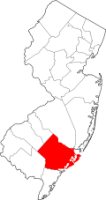
Atlantic County NJ Map
Atlantic County has some amazing history. With most of it's early settlers focused on seafood and utilizing the resources of the streams throughout.
This as stated in an old text by John W. Barber and Henry How published in 1844: Atlantic County is bounded NE by Burlington County, SE by the Atlantic ocean, South by Cape May County, SW by Cumberland County, and NW by Gloucester County. It is about 30 miles long by 20 miles wide and was formed from the eastern part of Gloucester County in 1837.
With a total area of 671.83 square miles, Atlantic County, New Jersey, topographically lies very flat. The highest elevation is only a mere 150 feet above sea level. The GIS mapping is important to the county for this reason.

To download or print this map of Atlantic County NJ on a full page please prove you're a human and solve the puzzle below ↓