

NJ County Maps
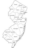
These are some quick facts about each New Jersey county as they pertain to population, year founded and square miles for the map.
The county links to the right of the page will take you to the corresponding county for the mapping and GIS information.
Atlantic County: was founded in 1837 and has a population of 274,338 residents. It's county seat is Mays Landing and the total area for the county map is 671 square miles.
Bergen County: was founded in 1683 and has a population of 911,004 residents. It's county seat is Hackensack and the total area for the county map is 247 square miles.
Burlington County: was founded in 1694 and has a population of 449,576 residents. It's county seat is Mount Holly Township and the total area for the county map is 819 square miles.
Camden County: was founded in 1844 and has a population of residents. It's county seat is Camden and the total area for the county map is 228 square miles.
Cape May County: was founded in 1685 and has a population of 97,265 residents. It's county seat is Cape May Court House and the total area for the county map is 620 square miles.
Cumberland County: was founded in 1748 and has a population of 157,095 residents. It's county seat is Bridegland and the total area for the county map is 489 square miles.
Essex County: was founded in 1683 and has a population of 785,137 residents. It's county seat is Newark and the total area for the county map is 130 square miles.
Gloucester County: was founded in 1686 and has a population of 289,104 residents. It's county seat is Woodbury (Walking Dead?) and the total area for the county map is 337 square miles.
Hudson County: was founded in 1840 and has a population of 641,224 residents. It's county seat is Jersey City and the total area for the county map is 62 square miles.
Hunterdon County: was founded in 1714 and has a population of 128,038 residents. It's county seat is Flemington and the total area for the county map is 438 square miles.
Mercer County: was founded in 1838 and has a population of 367,063 residents. It's county seat is Trenton and the total area for the county map is 229 square miles.
Middlesex County: was founded in 1675 and has a population of 814,217 residents. It's county seat is New Brunswick and the total area for the county map is 323 square miles.
Monmouth County: was founded in 1675 and has a population of 631,020 residents. It's county seat is Freehold Borough and the total area for the county map is 665 square miles.
Morris County: was founded in 1739 and has a population of 494,976 residents. It's county seat is Morristown and the total area for the county map is 481 square miles.
Ocean County: was founded in 1850 and has a population of 579,369 residents. It's county seat is Toms River and the total area for the county map is 916 square miles.
Passaic County: was founded in 1837 and has a population of 502,007 residents. It's county seat is Paterson and the total area for the county map is 197 square miles.
Salem County: was founded in 1694 and has a population of 65,902 residents. It's county seat is Salem and the total area for the county map is 373 square miles.
Somerset County: was founded in 1688 and has a population of 324,893 residents. It's county seat is Somerville and the total area for the county map is 305 square miles.
Sussex County: was founded in 1753 and has a population of 148,517 residents. It's county seat is Newton and the total area for the county map is 536 square miles.
Union County: was founded in 1857 and has a population of 539,494 residents. It's county seat is Elizabeth and the total area for the county map is 105 square miles.
Warren County: was founded in 1824 and has a population of 108,339 residents. It's county seat is Belvidere and the total area for the county map is 363 square miles.